Monday, February 26, 2024
Introduction / Overview
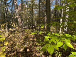
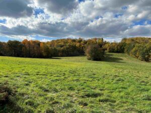
The Shaftsbury Solar Project is in Shaftsbury, Vermont, saddled between Hale Mountain and Harrington Cobble, on a property with 182 acres of mostly gently rolling fields and forests. Approximately 104 acres have been proposed for development into a solar electric generation facility. Solar panels for 20 MW electric generation will be placed on 80 acres. Further clearings of forests, fields, and soils are called for to remove shade-casting trees, create temporary laydown yards, onsite graveled access roads, temporary new access for heavy-duty vehicles, and a stormwater management system that includes scraping soil to build berms and installation of five gravel wetlands. (SS-AC-2(Revised) Section 248 Natural Resources Assessment, Mitchell Jackman; Adam Crary, January 16, 2024, and Section 248 Waste Disposal, Soil Erosion Technical Memorandum, Lydia Lee and Stephanie Wyman, PE, Civil Engineer.)
Rich Northern Hardwood Forest
Rich Northern Hardwood Forest is the predominant forest on the site. Dry Oak Maple Limestone Forest stands along the western side of the property and on the side of Hale Mountain. Plans are to cut, stump, and scrap soil for 41.8 acres of Rich Northern Hardwood Forest trees. At the neighbor’s request, a stand will be left untouched along the northeast border to screen the view from Holy Smoke Road. Many of the forest trees are in stands that separate the fields. The developer dismisses these swathes of forest as being hedgerows (without any hedges) because forest laws do not protect shrubs. Much of the forest that will not be cut are timbered woodlots closer to the road of trees less than forty years old.
The old-growth forest trees, sugar maples, white ash, and red oaks have very large heights and diameters; for example, sugar maples measured in November 2023 were found to be 6’ 10” and 7’ 11” in diameter breast height. One large maple consisted of three trunks from one stump, indicating that this sugar maple, according to its roots, is more than two hundred years old.

A large white ash (5’ 3” dbh) was standing dead. These trees live to be two hundred years old, and there was no telling how long this sturdy specimen had stood dead. The bark of the white ash was unblemished and completely intact. Surprisingly, there was no evidence of the emerald ash borer. The insect native to Asia, first detected in Michigan (2002), made its way to Concord, New Hampshire, by 2013. The forests of Pleasant Valley Wildlife Sanctuary in Lenox, Massachusetts, seventy-five miles to the south, are infected by the emerald ash borer and will likely lose all white ash trees. White ash trees in thirty states are dying from this beetle. Yet, in Shaftsbury, all of the white ash trees I saw had pristine bark. There was no evidence of emerald ash borer in Shaftsbury.
Large red oaks line the fields and back into the woods. One red oak had three trunks, having grown from an old red oak stump. One trunk was 8 feet 9 inches diameter-breast-height (dbh). The two trunks were fused at breast height and measured 11 feet 2 inches in diameter.
A young hawthorn tree was in the understory. The name haw comes from the Old English for hedge, appropriate for this tree in an old hardwood stand separating two fields. Hawthorns have red berries that will stay on the branch throughout the winter. Hawthorn provides food for rough grouse, pheasant, gray fox, rabbits, and whitetail deer. Hawthorn berries are a favorite of thrushes and cedar waxwings.
In the forests that bordered the fields were some large, old, black birch (sweet birch Betula lenta) and ironwood (hophornbeam, Ostrya virginiana). Bitternut hickory (Carya cordiformis) and Butternut (Juglans cinerea) stand tall. Beneath the high canopy were striped maple (Acer pensylvanicum), round-leaved dogwood (Cornus rugosa), and silver birch (Betula pendula). American beech (Fagus grandifolia) was established as understory trees in a few locations. Beech and, on the forest floor, Christmas ferns indicate an old-growth forest.
 Taconic Mountains of Limestone and Marble
The surprising size and vigor of northern hardwoods on the Shaftsbury Solar Site are due to the bedrock geology of the Taconic Mountains. Here are limestone, dolostone, and marble layers, sources of calcium and magnesium protected by shale and slate. The gently rolling topography enhances nutrient-rich soils to stay in place to become deep, moist, and compost-like.
The forests of Vermont’s Taconic Mountains have arguably the greatest diversity of tree species and, due to extraordinary nutrient-rich soils, the most remarkable growth. This forest excels at pulling carbon dioxide out of the atmosphere, growing biomass, and pushing out carbohydrates as root exudates to build soil.
Vermont’s Taconic Mountain range, approximately 700 square miles, rises West of Rutland, Vermont, north to Taconic Ramble State Park in Castleton, and south to Shaftsbury. These verdant mountains cover only 7% of Vermont’s landscape (9,616 square miles). Within this area stand precious few acres of old-growth Rich Mountain Hardwoods. About 40 acres border the fields of the Shaftsbury Solar Site.
Resilience
Researchers are discovering that increased plant species diversity increases forest resilience to climate change onslaughts of extreme weather, droughts and deluges, infestations, and invasives. In a controlled study, Douglas fir seedlings were given spruce budworms. The trees’ plant cells responded by emitting an enzyme into fungal strands. This signal traveled through the mycorrhizal network to bacteria—specific bacteria responded by producing defense enzymes that were transported back to the fir trees.
Surprisingly, within twenty-four hours of introducing spruce budworms to the fir trees, ponderosa pine seedlings nearby received the same defense enzymes via the fungal wood wide web in the soil. The greater the diversity of plants, the larger the gene pool for viruses to manipulate within bacteria, and the greater the arsenal of new defense enzymes for all.
Old Growth Forests
Most of the 41.8 acres of forest slated to be cut and stumped are old-growth northern hardwoods. The amount of carbon pulled out of the atmosphere by old-growth forests has been underestimated. Harvard Forest researchers in Massachusetts observed that an 80-year-old forest drew down and stored more than twice the carbon of a 40-year-old forest. Every tree with a diameter at a breast height of 40 inches or more added an annual 4 to 8 inches of biomass.
The researchers found that Eastern white pines over 150 years old accumulated 75% of their total carbon after the first 50 years. The most significant 1% of the trees in the forest were manufacturing about 30% of the biomass.
This is contrary to the belief that opening up the forest, perhaps following a clearcut, increased carbon drawdown due to more sunlight reaching the forest floor and the apparent fast upward growth of early successional woody plants. Opening up the forest canopy by cutting does not increase the overall wildlife value. Old-growth forests with plenty of cavities in large trees provide habitats for more woodpeckers, warblers, and thrushes.

The old-growth northern hardwoods slated to be cut and stumped are swathes of forests separating fields or surviving as beauty strips. Beauty strips are a forestry term for swathes of forest that are left in a natural state to hide the scars of clear-cutting. With much light from the fields and nutrients from the ground, sugar maple, white ash, red oak, black cherry, ironwood, and others are thriving. The narrow forests provide roosts for birds that hunt the fields. This ecotone has greater wildlife value than a forest block.
Pine martens prefer old-growth forests. One hundred fifteen martens were introduced to southern Vermont in the 1990s. This is the southern extent of the pine marten’s habitat, which is mainly in Canada. They were finally seen in the mid-2000s. Subsequently, three were caught in traps. Pine martens compete with larger fishers. Martens are better diggers, burrowing through the snow. With a larger paw-to-body weight ratio, martens bound over the snow while fishers struggle. With climate change decreasing periods of deep snow winters, the future of pine martens in Vermont is challenging. It will be bleak for pine marten if we continue to cut down old trees, including the large trees bordering the fields at the Shaftsbury Solar Project site.
 Carbon
The above-ground biomass of woody plants and field perennials holds an overall average of a third of the carbon. Living roots are estimated at 25 to 40% of the above-ground biomass. Soil organic carbon makes up the rest of the carbon. Carbohydrates are 3.67 times as big as carbon dioxide molecules. One ton of organic carbon in biomass and soil results from drawing 3.67 tons of carbon dioxide out of the atmosphere.
Two studies were consulted to estimate how much less carbon dioxide will be pulled from the atmosphere with the loss of 41.8 acres of old-growth forests. Massachusetts Audubon reported the loss of 5,000 forested acres, which resulted in 260 tons of carbon per acre storage in a year. For 41.8 acres, that is 13,757 tons of atmospheric carbon dioxide not stored in the soil.
USDA researched 12 northern hardwood forest blocks in Vermont, New Hampshire, and Maine. They reported a carbon stock of 216 tons per hectare. For 41.8 acres, that is 13,346 tons of atmospheric carbon dioxide.
The old-growth trees that border fields benefit from increased sunlight and better soil nutrients from the limestone and marble bedrock. These trees draw and store more carbon than the forest blocks referenced above, closer to 15,000 tons of carbon dioxide a year. The carbon storage of the forests scheduled to be removed on the Shaftsbury Solar Project is equivalent to the removal of 3,000 cars.

Grasses
Grasses are the champions of the plant kingdom for putting the greatest percentage of sugars and carbohydrates into the soil. When most plants photosynthesize carbon dioxide and water into liquid carbon, two-thirds goes to build plant biomass, and one-third is root exudate. About half of the carbohydrates manufactured by grasses go to the soil, and one-half is retained. With good weather conditions, grass can build an inch of soil in a year. A 240-square-foot plot of grass with an inch of soil has about one ton of organic carbon.
Soil
Soil is the elephant in the remediating climate change room. The world’s soil contains three and a half times as much carbon as in the atmosphere. That’s 2800 billion tons of organic carbon in soils compared to 800 billion tons of carbon dioxide, at 420 parts per million (ppm) carbon. To restore the planet to 350 ppm or 700 billion tons, 100 billion tons of carbon must be removed from the atmosphere and stored elsewhere.
Planting trees is a start. However, all of the biomass in the world amounts to 564 billion tons of carbon. To store 100 billion tons of carbon in biomass would necessitate a 20% increase in the weight of all animals and plants. A 100 billion tons of carbon into the soil is easier, just a 4% increase (100/2800). In soil, carbohydrates and minerals go through a chemical process to become humus. Humus will bind and store carbon for thousands of years, long-term storage. In wood biomass, carbon is stored for hundreds of years, which is short-term storage.
More carbohydrates in the ground fuels more life. Organic carbon acts as tiny sticky springs holding apart minerals with much space for water and air. Interstitial spaces are so large that four inches of soil can hold seven inches of rainwater. In a positive feedback loop, more soil with nutrient-rich water enables photosynthesis, more carbon pulled from the air, and more growth, biomass, and soil production.
Microclimate
Plants control our immediate microclimates. When it is hot, plants open small pores, called stomata, to release water vapor that evaporates and cools. Conversely, during the coldest hour before dawn, plants again open stomata to release water vapor that condenses to release heat that warms the microclimate. The morning dew starts warming before the sun’s rays hit the ground.
Evapotranspiration from plants varies greatly with location. Locally, it is responsible for 10% to 80% of rainfall. Removing plants to leave dirt, concrete, glass, or steel destroys this natural process of regulating microclimates.
Without vegetation, heat islands develop that reradiate 60% of the sun’s energy back into the atmosphere, warming the atmosphere. Solar energy that falls on plants is partially consumed and dissipated in evapotranspiration. Latent heat in the water vapor lifting off plants rises to cool and condense. Only 20% of the solar energy is reradiated from plants. There is three times less warming of the atmosphere with plants.

Surface temperatures on a hot summer day were measured on a plot of land in the Czech Republic that resembles the Shaftsbury site. The area with asphalt was 120 degrees Fahrenheit. The harvested meadow was 109 degrees. Sparse vegetation, 97 degrees. The wet meadow, alder stand, and forest were relatively cool at 84 degrees.
There’s more. Plants also release bacteria, fungi spores, and pollen that float in the air. Water vapor nucleates clusters around bacteria. It takes about a million bits to form a water droplet heavy enough to fall. Much less to form clouds.
Degraded lands, urban scapes, and industrial sites of glass and steel release dust particles. Water vapor gathers around particles of dust. However, an electrical charge prevents the particles from coming together. Instead, it all stays suspended in the air to form a haze. The haze will absorb heat, further warming the atmosphere and drying the landscape below.
Cumulus Clouds
The cumulus clouds from water vapor nucleating around bacteria and fungi reflect solar energy away from the planet. Forty years ago, the world was surrounded by more than 50% cumulus clouds. It is less than 50% today, and we have global warming. A difference of 1 to 2% cumulus cloud cover made all the difference.
Conversely, high cirrus clouds reflect heat back to Earth and warms the atmosphere like other greenhouse gases. Water vapor accounts for 80% of greenhouse gases, while carbon dioxide accounts for 11%. All the other gases, including methane and nitrous oxide, compose 8% of the world’s greenhouse gases.
Climate change modelers ignore water vapor because it is too dynamic. Water changes rapidly between the states of solid, liquid, and gas. A fourth state of water includes surface tension and the interactions between boundaries that do not fit into our understanding of solids, liquids, and gases (but are understood by water striders and sea skaters (Halobates)). Water is so uncooperative, not fitting into their equations due to its changing nature, that modelers have agreed to ignore water vapor. The problem with this approach is that everyone else, especially decision-makers relying on “the science,” assume water is not a factor when addressing climate change.

Biotic Water Pump
Old-growth forests emit significantly more water vapor than do managed woodlots. Local air pressure decreases when the rising moist air condenses to form clouds. This pressure gradient draws in moist air from elsewhere. Instead of forests just growing where the wind brought moisture when plants colonized the land, they evolved the ability to regulate atmospheric humidity. Plants draw moisture to them by releasing bacteria and fungi spores that drift in the air. Water vapor nucleates into cloud droplets. A 10% rise in relative humidity can lead to two to three times the amount of precipitation.
The biotic pump theory challenges the long-standing conventional wisdom that winds are driven primarily by pressure differences created by temperature changes. Atmospheric physicist Anastassia Makarieva explains that the idea of forests pulling in their own rain is not radical. “All organisms possess knowledge of physical laws that allow them to use the environment. We are not surprised when birds build nests. As soon as plants colonized land, they began to evolve the ability to regulate atmospheric humidity and draw it further inland. The climate problem is not just about carbon. It’s very much about water transport, which is strongly influenced by vegetation cover. This plays a huge role in weather patterns and weather extremes.”
Understanding the biotic pump concept will improve weather forecasting of large-scale climates because it picks up where atmospheric circulation models that only consider temperature effects leave off.
With the loss of old-growth forests and the absence of the biotic pump, water vapor remains over the oceans, and hurricanes become more damaging. Old-growth forests actively protect Vermont from extreme weather events while profoundly improving water yields.
Cutting the 40 acres of mostly old-growth forests on the Shaftsbury Solar Project site will diminish cumulous cloud formation and increase the energy of storms elsewhere.
Wildlands
Recently, a strategic step was taken to expand Vermont’s permanently protected wild natural areas. Wildlands in New England: Past, Present and Future is the first report in the nation to characterize all forever-wild lands in a single region. The report was compiled by Vermont-based Northeast Wilderness Trust, Harvard Forest, Highstead Foundation, and more than 100 nonprofits and public agencies.
Wildlands differ from woodlands because they can develop without significant human intervention once designated. They may be in any current condition from past human use, not necessarily a stand of trees. Wildlands have legal protections to become old-growth forests over time by going through the natural succession of plants. There’s a distinction between wildlands and woodlands. Woodlands are permanently conserved forests that are or can be actively managed.
The report reviewed 652 permanently protected properties and identified 426 properties (1.3 million acres) as places that met the Wildland criteria of intent, permanent protection, and management for natural processes. Forests cover 81 percent of the six-state region, and only 3.3 percent of New England’s 32.6 million acres qualified as wildlands. Of the 9.1 million acres of permanently protected forests, 13.5 percent are wildlands.
In Vermont, where 74% of the state is forested, only 12% of protected forests are designated wildlands. Vermont’s portfolio of Wildlands is spread across federal ownership (54 percent; U.S. Forest Service), state agencies (31 percent; primarily Department of Forests, Parks, and Recreation), and the nearly 27,300 acres (12 percent) owned by conservation organizations.
While relatively low in acreage, Vermont has twice or more as many parcels of land designated wildlands than other New England states (Vermont’s 157 compared to 85 in Maine, which is 37% of the 426 properties). With many smaller wildlands, Vermont comes the closest to meeting Henry David Thoreau’s vision of a natural park in every town.
Vermont has a vision to increase old forests (woodlands plus wildlands) to at least 9% of the existing forest and has strategically invested in conservation. On June 12, 2023, the Community Resilience and Biodiversity Protection Act became law. The act aims to permanently conserve 30% of all land in Vermont by 2030. By 2050, Vermont’s policy aims to conserve 50% of all land.
The Act builds on the work Vermonters have done to care for the landscape. Unlike the previous bill submitted a year ago, this resiliency and biodiversity act better balances conservation goals with Vermont’s need for more housing. It ensures that future conservation investments do not impede the buildout of areas that the state has designated for growth.
Wildlands are defined as a mix of farms and forests, managed parcels, and land left fallow. The patchwork of working fields and a mix of early and late successional forests make the Shaftsbury Solar Project site one of Vermont’s most valuable wildlands.
Stormwater Management
It appears that the design of the stormwater management system has progressed to higher detail. Without providing a basis of design, including the routing calculations, sizing of the gravel wetlands, and soil investigations, for example, it is not possible to determine if what is being proposed is realistic and reflects the actual level of disturbance and protection to resources required. The engineer did not provide any identification for the various basins and only provided vague descriptions of the potential limits of earth disturbance. Each level spreader and gravel wetland should be identified by name. Reviewing these plans and details is essentially useless without supporting reports and documentation.
Level spreaders must be perfectly level or they will promote concentrated flow. If not carefully maintained, there is a high propensity to cause erosion and impact wetlands. The limit of disturbance must be expanded downhill to allow the facility manager to access the reach in the event of a sediment discharge or erosion. A paper prepared by Mr. Domenic Rocco, PE., CPESC, Chief, Permits and Technical Services Section, Watershed Management Program, PADEP, describes that once flow passes the level spreader lip, the flow concentrates into 1/3 of its width, creating higher erosive velocities. There were no calculations provided to evaluate downslope stability to protect regulated water resources.
Over time, the proposed gravel wetland with two feet of gravel and pipes will become clogged.
Will there be an escrow account for DEC to enforce the maintenance of these structures? At every drainage point location that discharges offsite, the application needs an extension of the limited disturbance where the erosion will eventually occur when level spreaders don’t function properly or fail.
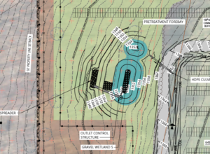
The level spreader on Site Plan C2.08 has a five-to-one (5:1) slope. This will not be stable in a good rain.
The mulch berms across the area for panel installations have breaks in them. How will the flow through breaks be controlled? Will there be silt basins? What is the potential for being overtopped by water?
Where is the phasing plan for cutting, stumping, and stripping the land? How will the 104 acres be parceled for stripping or at least the work that can initiate “indirect disturbance” (term used in the description by the applicant’s engineer) in keeping with the Vermont Standards and Specification for Erosion Prevention & Sediment Control?
The plans do not show where soil will be stripped and where soil will be left intact. Earlier plans talked of stripping most of the area to build berms.
When the “impacted primary agricultural soils” are stripped from fields and stockpiled, the biological and mineral components that make them fertile are destroyed. Soil containing life becomes lifeless dirt.
There is no indication that the most nutrient-rich, prime farmland soils will be demarcated, separated, and preserved. It looks like soil will be mixed and stored in arbitrary piles.
Stockpiled soils must be protected from rainwater leaching of nutrients, causing nitrogen pollution in rivers, cooking as microbes decay, erosion, and the gassing out of greenhouse gases, sulfides, carbon, and methane.
While the Project may not cause “unreasonable soil erosion or reduction in the capacity of the land to hold water” for an industrial site, “the indirect disturbances” will be significant. There will be disturbances to the entire 104 acres. Heavy machinery must drive to the gravel wetlands at the five corners of the site to install erosion prevention and sediment control berms and basins. All posts and pads must be driven with tracked machines. Trucks must deliver all materials. Soils will be rutted and compacted, which will cause increased runoff velocity and erosion issues. The sediment basins appear too few or too small. It is hard to say when no EPSC or post-construction stormwater management reports with calculations were provided.
Shaftsbury Solar should be bonded, similar to the decommissioning requirement, to ensure all the maintenance for stormwater management systems to protect wetlands and regulated resources downstream.
We are told solar farms preserve the land. Yet, that is a stretch. Once they are done, the poles and pads will be pulled out. Once again, the land will be rutted and compacted when panels and equipment are removed. How will soil permeability be restored? Will runoff and erosion become problematic? How will soils be amended? How will the characteristics of “prime farmland soils” be replicated? The soils that are spread will likely not be as productive or absorbent as those here today. The 104 acres of Vermont’s finest farmland will be degraded.
Shaftsbury Solar must manage the receiving watersheds to repair or remove sediment outside of their areas of disturbance. There is a high potential for sediment deposition in wetlands and streams.
The report does not say how long Shaftsbury Solar will operate in the future. The Project has been engineered to meet the Water Quality Standard, which provides treatment for the 1-inch storm event. The standard is based on the history of rainfall in the area. The project does not consider the increasing volume of rain suffered by Vermont in recent years or prepare for what is to come.

It is easy to underestimate the power of stormwater. On January 12, 2018, scattered showers brought 1.95 inches of rain to the Dynamic Energy Solutions solar project in Williamsburg, Massachusetts. On 18.5 acres in a former sand and gravel pit, Dynamic was installing a 4-megawatt, 17,000-panel solar energy array.
According to the lawsuit that followed, sediment-laden stormwater barreled off the site, eroding the hillside, scouring out perennial and intermittent streams, uprooting trees, destroying streambeds, filling in wetlands with sediment, and causing the cold-stream river to become brown.
Mismanaged stormwater altered approximately 97,000 square feet of protected wetlands and more than 41,000 feet of riverfront area and smothered the West Branch of the Mill River. Wildlife habitats and vegetation were destroyed, and the flow of the tributaries into the river changed.
Dynamic Energy Solutions was compelled by the courts to pay $530,000 to restore impacted resources, place a parcel of 24 acres near the West Branch Mill River into conservation at an estimated cost of $210,000, pay $215,000 to fund the acquisition of land by a trust to benefit water quality, pay a penalty of $100,000 to the state’s General Fund, and pay $80,000 to the AG’s Office for costs.
Vegetated Watershed
The legacy of Vermont’s vegetated watersheds cannot be overstated despite efforts to keep everyone’s focus on carbon emissions and rising greenhouse gases as the only cause of climate change. Dennis Meadows of Cobb Hill, Hartland, explained how the climate system is like a bathtub. When the incoming flow is equal to what is going down the drain, the system reaches equilibrium. The climate change tub is filling with more greenhouse gas emissions than the drain can handle, and we suffer. Turning down the figurative faucet will not keep the tub from eventually overflowing. Only by enlarging the drain with more photosynthesis by plants with carbon stored in soils can the atmosphere be restored to 350 ppm carbon.
With much talk about carbon dioxide in the atmosphere, they did not see, like the emperor with no clothes, that the land had been stripped of vegetation and degraded.
George Perkins Marsh saw more clearly back in 1847. When speaking to the Agricultural Society of Rutland County, Vermont, he described the situation: “Man cannot at his pleasure command the rain and the sunshine, the wind and frost and snow, yet it is certain that climate itself has in many instances been gradually changed and ameliorated or deteriorated by human action. The draining of swamps and the clearing of forests perceptibly affect the evaporation from the earth and, of course, the mean quantity of moisture suspended in the air. The same causes modify the electrical condition of the atmosphere and the power of the surface to reflect, absorb, and radiate the rays of the sun, and consequently influence the distribution of light and heat and the force and direction of the winds. Within narrow limits, domestic fires and artificial structures also create and diffuse increased warmth, to an extent that may affect vegetation.”
Marsh explained that deforestation leads to desertification. He noted that once lush lands gone to deserts around the Mediterranean from Morocco across the Sahara to the Steppes of Asia and Mongolia, “the operation of causes set in action by man has brought the face of the earth to a desolation almost as complete as that of the moon.”
Environmental degradation and resource scarcity result from misbalancing an environmental equilibrium, said Marsh. As long as we manage to keep resources in good condition, the welfare of future generations will be secured.
Much of the Adirondack Forest was timbered following the Civil War. Marsh argued in 1875 that if the watershed were allowed to deteriorate, there would be insufficient groundwater to provide rivers with adequate water. The Erie Canal would cease to be navigable for the barge transport that was vital to New York’s burgeoning economy. As a result, the Adirondack State Park (9,375 square miles) was created for watershed protection, and commerce continued on the Erie Canal.
The waters are not so deep in the Mississippi River because Marsh’s words were forgotten, and why the Adirondack Park was created has been forgotten. In the fields and woods on the property beside Holy Smoke Road, we have an opportunity to remember the wisdom of Vermonters Meadows and Marsh
Recommendations
The old-growth sugar maples, white ash, and other northern hardwood trees on the Shaftsbury Solar Project site are pulling massive amounts, 15,000 tons, of carbon dioxide per year out of the atmosphere and storing carbon in soil and biomass. This extraordinary amount of carbon transfer is unique in Vermont due to the sweet soil of the Taconic Mountains, which is high in calcium and magnesium, and the forest trees bordering the fields receiving more sunlight.
In keeping with Vermont’s Community Resilience and Biodiversity Protection Act, the 41.8 acres of forest should remain standing. The great diversity of tree species found in these stands increases the resilience of the forest. The great genetic diversity, mycorrhizal networks, and healthy vigor may be responsible for the absence of emerald ash borer killing white ash trees. To my knowledge, white ash trees in the rest of New England and New York forests are dying from this parasite.
Leaving the trees standing reduces the three-fold increase in reradiated heat when vegetation is replaced with dirt, cement, steel, and glass. Trees moderate the microclimate with cooling evaporation and warming condensation. Northern hardwoods cool with shade during the hot summer months and warm with bright sunlight from November to April. Trees release bacteria, fungi spores, and pollen that floats in the air. Water vapor will nucleate to form mist and cumulus clouds. Cumulous clouds reflect sunlight away to cool. Cloud formation lowers atmospheric pressure, draws in more moisture, prevents drought conditions, and keeps Vermont green.
These northern hardwoods with deep, moist,nutrient-rich soil will continue to increase in wildlife values as they age. Here are habitats for rare and uncommon plants such as Goldie’s wood-fern, broad beech fern, wood millet, puttyroot, wild ginger, and Hooker’s orchid—wildlife benefits from the mix of field and forest, with many roosts and nesting cavities.
The 104 acres cleared and soil scraped for a solar industrial park will result in bare ground compacted and rutted by heavy machinery that must be driven to all corners of the property to install gravel wetlands, build berms, and construct facilities. Absent from the stormwater management plan is a program to keep the gravel wetlands from clogging with leaves and detritus. Shaftsbury Solar will not manage the receiving watersheds to repair or remove sediment outside their disturbance areas. Engineered to provide water treatment for the 1-inch storm event, there is a high potential for sediment deposition in wetlands and streams.

The Ocean River Institute provides opportunities to make a difference and go the distance for savvy stewardship of a greener and bluer planet Earth. www.oceanriver.org